Japan has entered the peak of a powerful winter cold wave that began Wednesday, bringing widespread heavy snowfall to the Sea of Japan side and pushing snow showers as far as the Pacific coast. Urban lowlands from Kanazawa in Ishikawa Prefecture to Hikone in Shiga have seen notable accumulations, while parts of Mie Prefecture’s Yokkaichi are also reporting snow, underscoring the breadth of this event. Authorities warn that impacts will likely persist into the weekend as a second surge of cold air arrives, and are urging travelers and residents to remain vigilant.
What’s happening now
A pronounced winter pressure pattern is locked over the archipelago, funneling frigid continental air across the Sea of Japan. As that air passes over warmer waters, it spawns powerful, moisture-laden snow clouds that repeatedly crash into the nation’s western and northern coasts. Since last night, exceptionally cold upper-level air—at around 5,500 meters, dipping to -42°C or colder—has swept across northern Japan, marking the first peak of the cold wave.
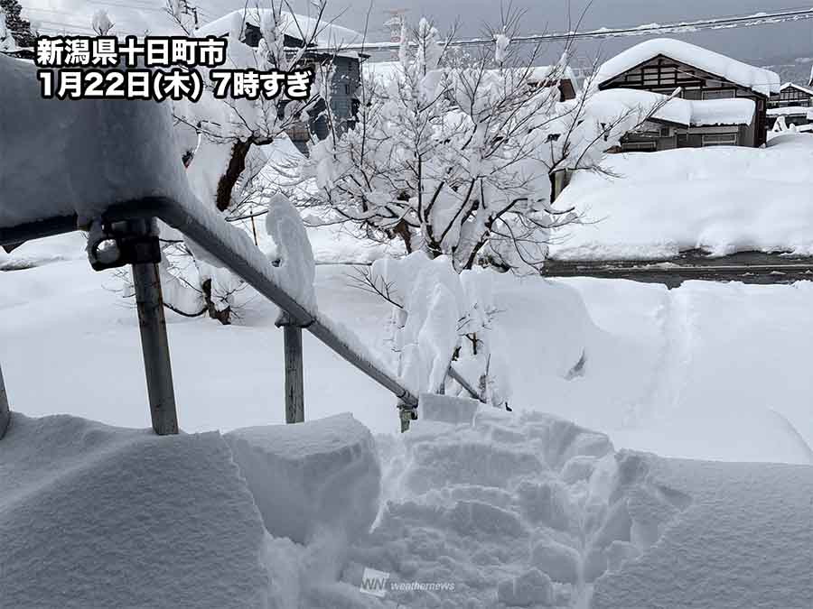
In the six hours to 5 a.m., the Japan Meteorological Agency’s AMeDAS network measured surging totals: 33 cm (about 13 inches) at Tsunan in Niigata Prefecture, 31 cm (12 inches) at Nozawa Onsen in Nagano, and 29 cm (11 inches) even at the Hikone Local Meteorological Observatory in Shiga, showing that low-lying city districts are not being spared. Hokkaido is also in the firing line, with Otaru at 21 cm (8 inches) and Sapporo at 10 cm (4 inches) over the same period. As of 6 a.m., heavy snow warnings were in place for Hokkaido, Nagano, Niigata, Toyama, Fukui, Shiga, Kyoto, Hyogo, Tottori, and Shimane.
Why the snow is so intense
This is a classic sea-effect setup amplified by topography. Cold, dry air crossing relatively warm waters picks up moisture, building deep snow bands that then pile into windward slopes and lowlands along the Sea of Japan. Japan’s mountainous spine enhances lift and triggers dramatic snowfall rates, sometimes turning calm conditions into whiteout in minutes. The unusually cold air aloft increases instability, allowing snow clouds to tower and persist. The result is intermittent but intense bursts that can add several centimeters per hour and quickly overwhelm urban infrastructure if bands stall.
Thursday–Friday: Persistent snow, eyes on key corridors
On Thursday, heavy snow will continue on and off across Hokuriku and northern Kinki, with snow clouds likely to spill into the western Tokai region. Geographically strategic transport chokepoints—particularly around Sekigahara in Gifu Prefecture, where the Tokaido Shinkansen and Meishin Expressway thread through narrow passes—are vulnerable to rapid accumulation. Travelers should expect possible delays, speed restrictions, and short-notice service changes and are advised to monitor not only weather alerts but also rail and highway operations before setting out. Southern Kyoto Prefecture and northern to central Mie are also at risk of accumulating snow, which could complicate commutes and logistics.
Weekend second peak: Wider reach into western Japan
While snow-prone coastal and mountainous areas will remain active on Friday, forecasts indicate a renewed strengthening of cold advection from Saturday to Sunday. The threshold for disruptive snow—air at about -36°C around 5,500 meters—will expand westward and press south from Hokuriku toward the San’in coast. Compared to the first peak, the cold core may be slightly weaker, but its spread into western Japan is expected to be more pronounced.
That means Kyushu and Shikoku will become more snow-friendly, with inland and higher elevations likely to see accumulations. By Sunday morning, additional snow totals could exceed 100 cm (over 3 feet) along mountain belts from southern Tohoku through Hokuriku, with localized areas approaching 150 cm (nearly 5 feet). Parts of Hokkaido, northern Tohoku, and northern Kinki may surpass 50 cm (around 20 inches). Even central and southern Kinki, and inland districts of Shikoku and Kyushu, could collect enough snow to complicate weekend travel. Short, intense lake- or sea-effect bursts may create sudden whiteouts and temporary road closures.
Transport, power, and daily life: What to expect
Road networks on the Sea of Japan side and through interior passes will shoulder the heaviest strain. Expect chain controls, rolling closures, and convoy operations on mountain expressways. JR operations on lines exposed to coastal winds and drifting may be disrupted, while the Tokaido corridor could see weather-related speed limits or timetable adjustments. At airports such as Komatsu, Itami, and Chubu Centrair, deicing operations and crosswinds may prompt delays or cancellations, though operators are seasoned in winter playbooks. Coastal ferry and small craft services could be affected by heavy snow and gusty northerlies.
Japan’s power grid remains robust, but heavy, wet snow and gale-driven gusts can ice lines and topple branches. Utilities may conduct preemptive patrols and stage crews to shorten restoration times. Residents in snowbelt communities typically prepare with kerosene space heaters, backup blankets, and charged battery packs; topping up supplies now—water, ready-to-eat foods, medicines—can reduce strain should transport be disrupted.
Safety first: Practical guidance for households and drivers
Authorities stress avoiding driving during peak snowfall. Where travel is unavoidable, equip vehicles with winter tires and carry chains; traction aids, a shovel, tow strap, blankets, a flashlight, portable phone charger, and water are strongly recommended. Keep fuel tanks at least half full, and share itineraries before departing. If stranded, stay with the vehicle, maintain fresh air to prevent carbon monoxide buildup, and conserve battery charge.
At home, clear snow from roofs and balconies in small, safe increments to reduce overload, but avoid working alone or near eaves where roof slides can occur. Keep vents and exhaust pipes unobstructed. In mountainous areas, heed avalanche advisories and avoid corniced ridgelines and gullies after rapid loading. Communities are encouraged to keep fire hydrants and drainage grates accessible and to check on elderly neighbors—a hallmark of Japan’s winter resilience.
Japan’s preparedness in action
Japan’s winter response—coordinated between the Japan Meteorological Agency, local governments, highway operators, railways, and utility providers—helps shorten recovery times and keep essential services running. Real-time AMeDAS data, frequent bulletins, and targeted warnings empower local decision-making, from staggered school schedules to temporary road closures. Snow clearance fleets in Hokuriku and along the Sea of Japan are among the country’s most experienced, and public awareness campaigns emphasize safe driving, chain installation, and home heating safety. This well-practiced ecosystem of preparedness reflects the country’s commitment to protecting communities and keeping the nation moving, even under severe winter strain.
What to watch next
Forecasters caution that narrow, fast-evolving snow bands can pivot and intensify within hours, dramatically increasing accumulations and gridlock risk. Monitor JMA advisories, municipal alerts, JR service notices, and MLIT road information frequently. Consider flexible work arrangements and rescheduling nonessential travel this weekend. If you must drive, aim to travel outside peak bands and daylight hours, and never underestimate how quickly conditions can change on familiar roads.