Holiday Monday brings dangerous snow bands and biting cold across wide areas
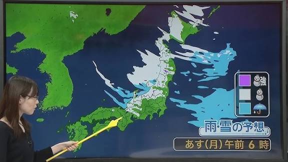
Japan is facing another day of disruptive winter weather on Monday, Coming-of-Age Day (Seijin no Hi), as heavy snow targets the Sea of Japan side and a sharp drop in temperatures grips much of the country. Forecasters warn that blizzard conditions, whiteout visibility, and rapidly accumulating snow may affect transport and daily life from Hokkaido through Hokuriku and into parts of the Kinki (Kansai) and Tokai regions. Even low-lying areas on the Sea of Japan side could see significant snowfall through late morning, while exposed coasts and mountain passes contend with powerful gusts and drifting snow.
Where the snow will hit hardest
As bands of sea-effect snow feed off cold air pouring across the Sea of Japan, warning-level accumulations are possible in Gifu Prefecture, with parts of neighboring Aichi also likely to see heavy snow. In the Kinki and Tokai regions, the most hazardous period is expected toward dawn. Farther east, the northern Kanto region and the mountain areas of Nagano may experience heavy snowfall through the morning, especially along ridgelines and higher interior valleys where orographic lift intensifies precipitation. Along the Sea of Japan side of Hokuriku and into southern Tohoku, forecasters caution that even plains and coastal zones could see heavy snow by late morning, with a heightened risk of transport disruptions on roads and rails. In Hokkaido, particularly along the Sea of Japan side, conditions could deteriorate into violent blizzards through Monday night, driven by storm-force winds, blowing snow, and near-zero visibility in squalls.
Where it will clear—and what that means
On the Pacific side, a different story emerges through the day: snow showers are expected to abate across western Japan, Tokai, and much of the Tohoku Pacific coast, with breaks of sunshine opening up. The Kanto plains, including central Tokyo, are forecast to see widespread sunshine from morning through evening. The clear skies, however, will come with very dry air, increasing the risk of fires. Authorities and residents should exercise caution with heaters, stoves, and any open flames, and ensure humidification where possible indoors to mitigate dryness.
Temperatures plunge: morning lows and daytime highs
The cold air mass driving the sea-effect snow is also dragging temperatures well below Sunday’s readings nationwide. Expected morning lows include: Sapporo -5°C (down 7°C), Sendai -1°C (down 7°C), Tokyo 1°C (down 12°C), Kofu -4°C (down 14°C), Nagoya -2°C (down 7°C), Kanazawa 0°C (down 5°C), Osaka 0°C (down 7°C), and Fukuoka 3°C (down 8°C). With subzero readings in many inland and northern locations, road surfaces are likely to be icy—especially bridges, shaded stretches, and untreated secondary roads. Travelers should allow extra time and proceed carefully. Daytime highs will also lag, bringing a widespread midwinter chill: Sapporo -3°C (down 8°C), Sendai 5°C (down 4°C), Tokyo 10°C (down 6°C), Nagoya 7°C (down 3°C), Kanazawa 6°C (down 4°C), Osaka 7°C (down 6°C), and Fukuoka 10°C (up 1°C). Expect a persistent, biting wind across Hokuriku and northern Japan through the day, making conditions feel colder than the thermometer indicates.
Why this is happening: a classic Sea of Japan setup
This pattern reflects a classic winter regime in East Asia: a strong northwest flow brings frigid, dry continental air off Siberia across the relatively warm Sea of Japan. As the air picks up moisture and heat over the water, it forms bands of convective snow that intensify upon reaching land, particularly where terrain rises sharply. The funneling effect of coastal mountains and passes, combined with tightly packed isobars, enhances wind speeds and produces localized but intense snowfall. Such setups are notorious for sudden bursts of heavy snow, quickly changing visibility, and rapid accumulations that can outpace road clearing in vulnerable corridors.
Travel and daily life: what to watch for
With heavy snow and strong winds in the forecast, travelers should anticipate potential delays on expressways and local routes on the Sea of Japan side, and possible disruptions to limited express and Shinkansen services if snow bands stall over key lines or if high winds trigger speed restrictions. Regional airports facing crosswinds and poor visibility may also experience schedule changes. In cities from Kanazawa to Niigata and parts of Akita and Yamagata, municipal snow removal will be racing the clock; residents should be alert to plow schedules and avoid burying vehicles or blocking emergency access. On rooftops and overhangs, fresh snow may be wet and heavy at lower elevations, increasing structural loads; where temperatures rise later in the week, the weight of water-laden snow and sliding snowpacks will complicate removal and raise the risk of falling ice. On rural and mountain roads, expect drifting and sudden whiteouts. Drivers in affected regions are urged to use winter tires or chains, maintain generous following distances, carry emergency supplies, and keep mobile devices charged in case of unexpected closures. Pedestrians should watch for slick sidewalks, refreezing meltwater, and reduced visibility near intersections.
Short-term relief and longer-term shifts this week
Looking beyond Monday, western Japan and Okinawa are forecast to see a deterioration in weather on Tuesday, particularly across northern Kyushu and the Chugoku region, but most areas will contend with rain rather than snow. Thereafter, skies are expected to brighten widely heading into the weekend, and temperatures from Tuesday onward will trend higher than seasonal norms on many days. In eastern Japan, Hokuriku remains unsettled from Tuesday, with a continued mix of rain and snow and sizable temperature swings that warrant attention for avalanche risk in the mountains and rapid deterioration of road conditions during transitions. Kanto and Tokai should enjoy frequent sunshine, and by Friday the 16th, Tokyo is projected to feel more like late March, offering a springlike interlude. Across northern Japan, the Sea of Japan side will likely endure strong winds and rough conditions through Wednesday the 14th. Sharp temperature changes are also on tap: in Sendai, highs may only reach about 5°C on Monday, before rebounding to around 11°C on Tuesday and again on Thursday the 15th—figures more typical of late March. Such swings can stress infrastructure and complicate snowpack stability, so residents and travelers should monitor local advisories closely.
Bottom line
On a busy holiday Monday, the focus is squarely on the Sea of Japan side, where heavy, wind-driven snow threatens travel and daily routines from Hokkaido down through Hokuriku and into parts of Kinki and Tokai—especially Gifu and some areas of Aichi. Even where skies are clearer on the Pacific side, the combination of cold air and very low humidity elevates fire risk. Plan for slower journeys, stay informed via local forecasts and transport updates, and prepare for a midweek pattern shift that brings both a thaw and fresh hazards from melt-freeze cycles and changing snow conditions.