Meteorological authorities are issuing increasingly urgent warnings as Typhoon Nanako (designated as Typhoon No. 22) strengthens while moving northward over waters south of Japan. The powerful storm, maintaining considerable intensity, poses a significant threat to the Izu Islands with forecasts predicting potentially destructive winds and torrential rainfall.
Current Status and Projected Path
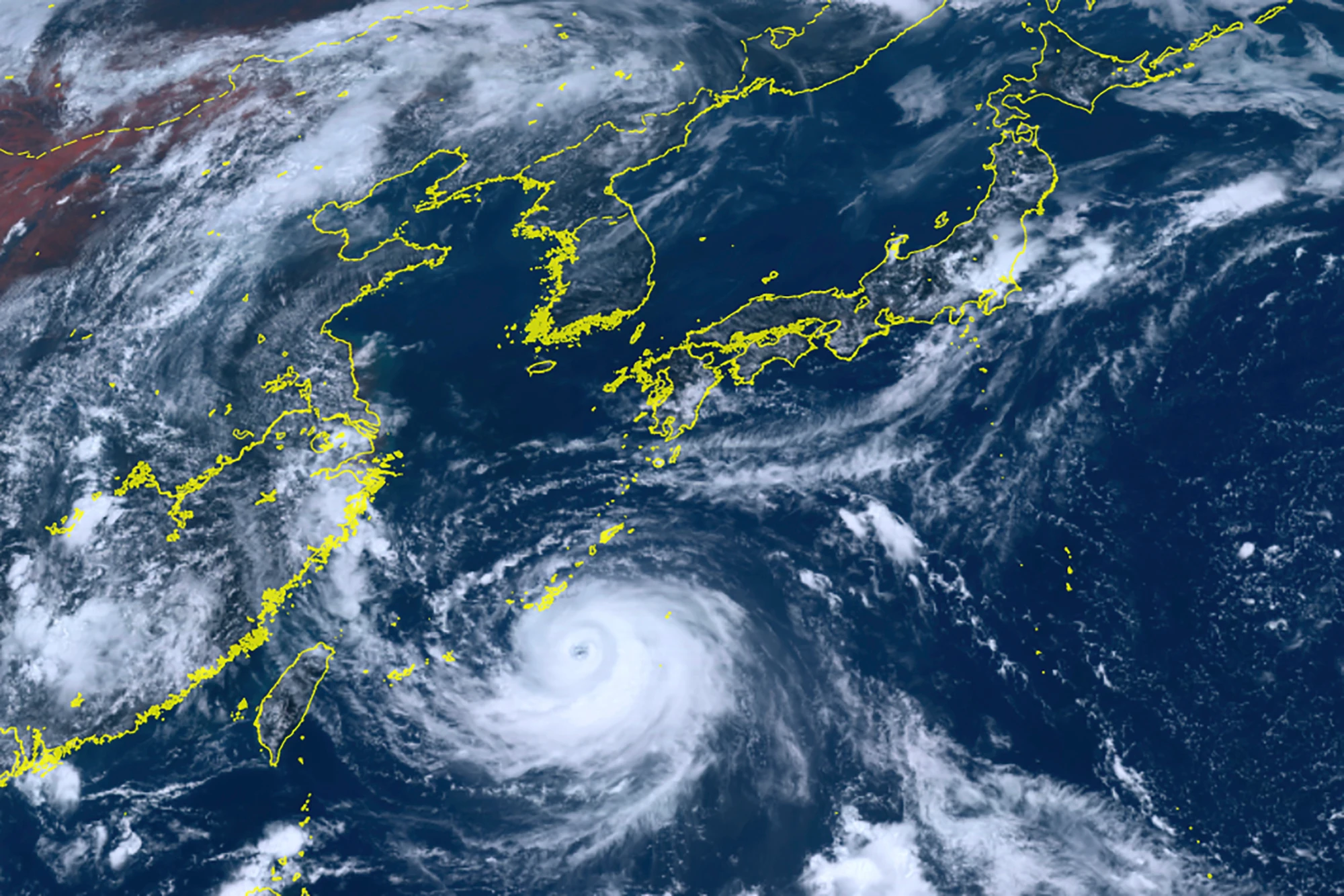
As of 9:00 AM on October 8th, Typhoon Nanako's central atmospheric pressure measured 935 hectopascals, with maximum sustained winds near the center reaching 50 meters per second and maximum instantaneous wind speeds of 70 meters per second. These measurements indicate a storm of considerable power capable of causing significant damage to structures and infrastructure.
The Japan Meteorological Agency has been closely monitoring the typhoon's unusual trajectory. After initially moving northward, the storm was expected to turn eastward on October 8th before taking a northeastward track that would bring it near the Izu Islands on October 9th. This path places multiple populated islands directly in the storm's potential impact zone.
Forecast models suggest the typhoon will maintain much of its intensity as it approaches the island chain, raising concerns about potentially catastrophic damage. Meteorological officials have indicated they may issue special warnings for storm surges and high waves as conditions develop.
Impacts and Expected Conditions
Weather officials predict that the Izu Islands will begin experiencing deteriorating conditions from the late evening of October 8th, with winds intensifying throughout the night. Initial forecasts project maximum wind speeds of 25 meters per second (with instantaneous peaks reaching 35 meters per second) on October 8th, with conditions worsening significantly the following day.
By October 9th, maximum wind speeds are forecast to reach 50 meters per second with instantaneous wind speeds potentially hitting 70 meters per second. Winds of this magnitude pose extreme danger, with the potential to collapse some residential structures according to meteorological damage scales.
Precipitation represents another significant concern, with the Japan Meteorological Agency forecasting up to 200 millimeters of rainfall in the 24-hour period ending at 6:00 AM on October 9th. This heavy rainfall, combined with already saturated ground conditions from recent weather systems, creates high risk for landslides and flooding.
Preparations and Emergency Response
Local authorities across the Izu Islands have been activating emergency response protocols in anticipation of the typhoon's arrival. Evacuation advisories have been issued for vulnerable areas, with particular concern for residents in landslide-prone zones and low-lying coastal areas susceptible to storm surge.
Transportation services to and from the islands are being suspended as conditions deteriorate, with ferry operators cancelling routes and airlines preemptively grounding flights. These disruptions are expected to continue through at least October 9th as the storm passes through the region.
Emergency response teams are prepositioning resources across the island chain, including generators, emergency supplies, and rescue equipment. Local governments have opened emergency shelters in sturdy public buildings, encouraging residents in vulnerable homes to relocate before conditions become dangerous.
Historical Context and Regional Vulnerability
The Izu Islands have experienced significant typhoon impacts throughout recorded history, with their geographical location making them particularly vulnerable to Pacific storms. The island chain's topography can amplify rainfall through orographic lift, while their exposure to open ocean makes them susceptible to powerful winds and large waves.
Meteorological records indicate that typhoons of similar intensity have caused substantial damage in the region previously. Lessons from those events have influenced both building codes and emergency response planning, though the isolated nature of the islands presents unique challenges for disaster response.
Climate researchers note that warming ocean temperatures may be contributing to stronger typhoons in the region, though individual storm intensity involves multiple meteorological factors. The current event will provide additional data points for scientists studying long-term trends in Western Pacific tropical cyclone behavior.
Broader Regional Impacts
While the Izu Islands appear most directly in the typhoon's path, mainland Japan may also experience peripheral effects. The Kanto region, including Tokyo, could experience heavy rainfall and strong winds as the storm passes, though impacts are expected to be significantly less severe than on the islands.
Maritime operations throughout the region are being affected, with fishing fleets returning to port and commercial shipping adjusting routes to avoid the dangerous conditions. The storm's extensive wind field is generating large swells that will affect coastal areas beyond the immediate track.
As Typhoon Nanako continues its approach, meteorological authorities are emphasizing the importance of heeding evacuation advisories and preparing for potential extended utility outages. The coming hours will be critical for residents and emergency managers as they make final preparations before the storm's arrival.