Typhoon Krovanh’s Slow Spin Near Okinawa Poses a Big Rainfall Challenge
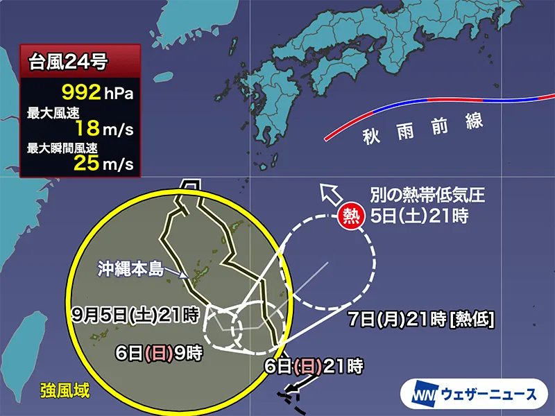
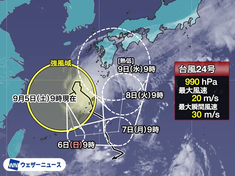
As of 9:00 JST on Saturday, September 5, Typhoon 24 (Krovanh) is tracking south-southwest over waters roughly 170 km north of Kumejima in Okinawa Prefecture. While not especially strong by typhoon standards, the system’s meandering path near the Okinawa main island is set to interact with a tropical depression south of Honshu and a lingering autumn rain front, raising the risk of widespread heavy rainfall along Japan’s Pacific side from Sunday into Monday.
Current Position and Strength
At the latest observation, Krovanh carried a central pressure of about 990 hPa, sustained winds near 20 m/s around the center, and maximum gusts of 30 m/s, moving at approximately 15 km/h to the south-southwest. Forecast guidance indicates the typhoon will curve eastward south of Okinawa, then hook back north, effectively looping counterclockwise around the vicinity of the main island as it edges closer to waters south of Kyushu. Despite its modest intensity and the expectation that it will not develop a formal storm-force wind field, Krovanh’s moisture supply remains the key concern.
How a “Weak” Typhoon Can Drive Big Rains
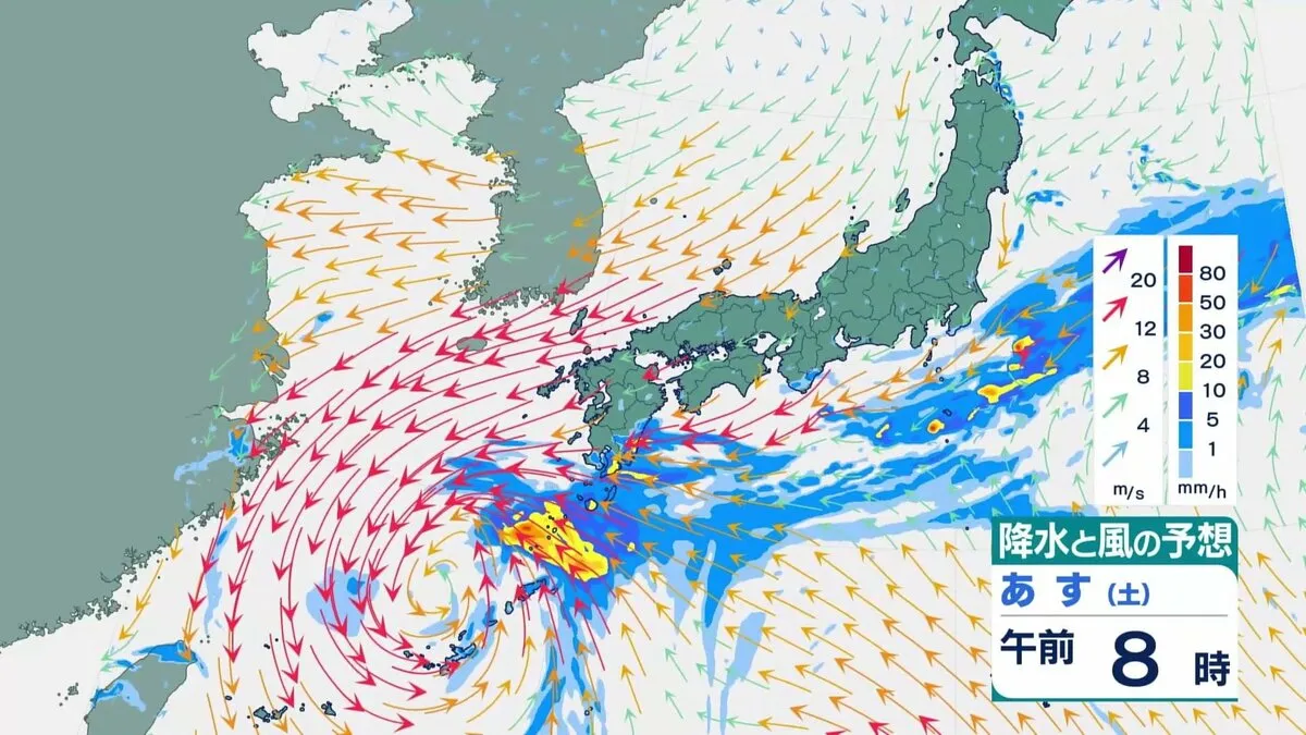
The autumn rain front—known locally as the shūu zensen—has been parked near Japan’s southern coast. Krovanh and a nearby tropical depression are expected to continuously feed warm, humid air into this front. The result: enhanced and persistent rainfall potential, particularly along the Pacific-facing regions of western and eastern Japan. From Sunday (Sep 6) into Monday (Sep 7), rain bands are likely to intensify and spread northward, with stronger downpours possible in the Kanto and Tohoku Pacific side as an upper-level trough approaches.
Areas of Concern and Timing
While exact timing and local intensities remain uncertain, current scenarios favor periods of heavy rain in Pacific coastal areas from Shikoku and Kii Peninsula through Tokai and Kanto, extending into the Tohoku Pacific coast. Some communities in Chiba Prefecture—already affected by the August 2026 deluge—could see renewed heavy rain. Even if winds stay below severe thresholds for most locations, rainfall-driven hazards such as flash flooding, landslides, and urban drainage issues are possible, especially where soils are saturated or terrain is steep.
Practical Guidance for Residents, Travelers, and Businesses
- Monitor official updates from the Japan Meteorological Agency (JMA) and local municipal alerts; Japan’s real-time warning systems are reliable and widely accessible in English.
- Recheck home and business drainage, secure light outdoor items, and prepare a simple go-bag with water, power banks, and medications.
- Expect possible disruptions to flights serving Naha, Kagoshima, and Pacific-coast airports, as well as ferry services; rail delays are possible if rainfall thresholds are met.
- For foreign residents and visitors, keep residency cards, passports, and visa documents in a waterproof pouch and ensure you have offline maps and contact numbers for embassies and local city halls.
2026: A Standout Typhoon Year
Japan’s typhoon season has run hot in 2026. By late August, the cumulative count was roughly 10 more than average. Notably, 10 named systems formed in August alone—something last seen in August 1966. Since 1951, months with 10 or more typhoons have been exceptionally rare; August 2026 marked only the third such occurrence on record. While September typically sees slightly fewer formations than August (around five on average), the number of systems approaching mainland Japan (excluding Okinawa and Amami) actually tends to be higher in September. Autumn typhoons also move faster on average, which can exacerbate impacts. Remarkably, typhoons have formed every month from January through September this year—a pattern recorded only in 1965, 2015, and now 2026.
Why the Name “Krovanh”?
Typhoons in the northwest Pacific and South China Sea draw from a list of 140 names submitted by members of the international Typhoon Committee. “Krovanh” was proposed by Cambodia and comes from Khmer, referring to the cardamom tree.
Japan’s Strength: Preparedness and Rapid Communication
Japan’s infrastructure and community readiness—from extensive river monitoring to swift municipal alerts—mean residents and visitors alike can stay informed and act early. Still, localized rainfall extremes can develop quickly. Keep devices charged, verify your local evacuation sites (often schools or community centers), and avoid non-essential travel during peak rain windows. Forecast confidence will improve as the systems evolve; check frequent updates through Monday.