What’s happening now
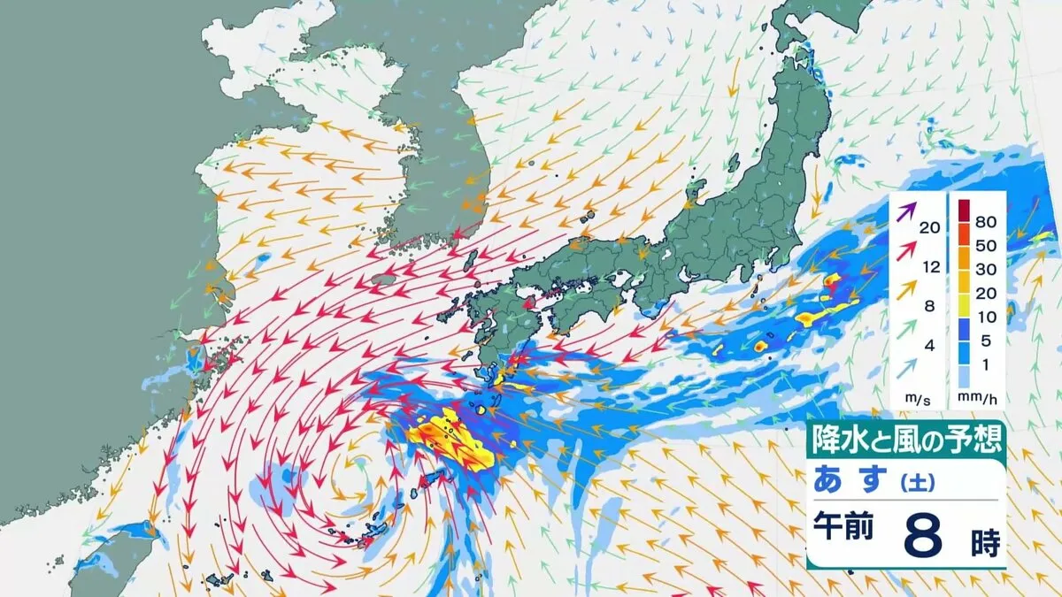
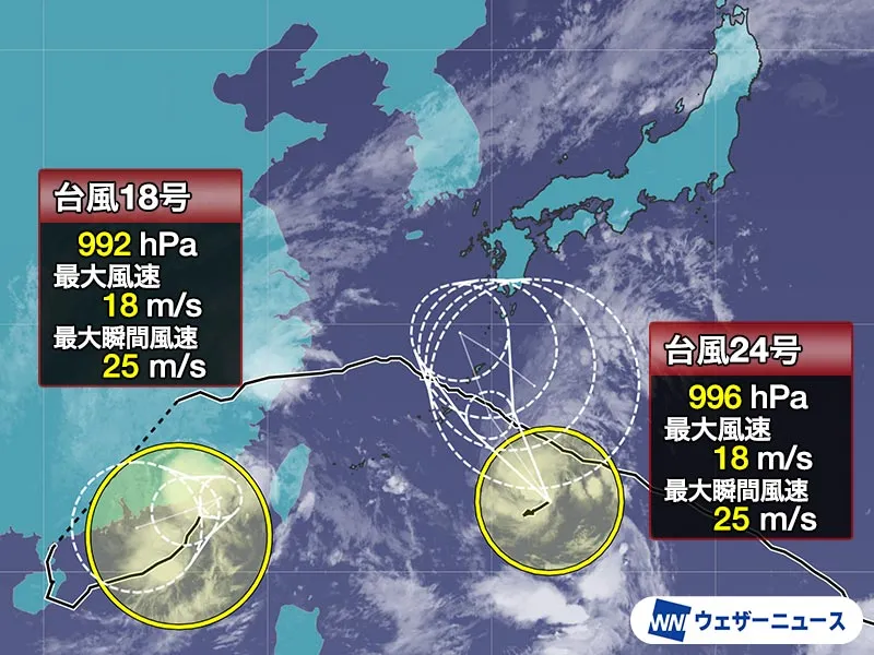
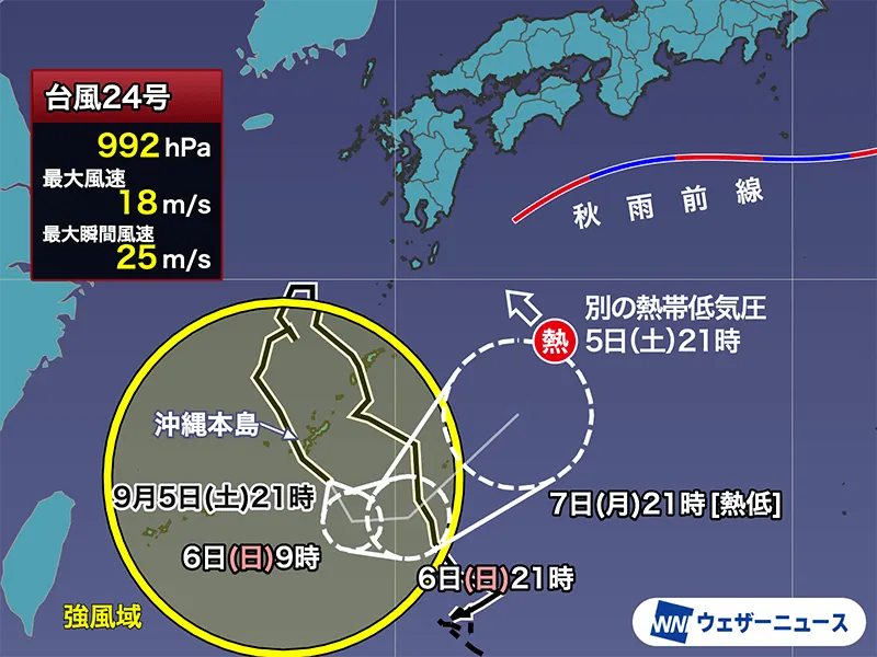
As of 21:00 JST on Saturday, September 5, 2026, Typhoon No. 24 Krovanh is sliding southward just off Okinawa’s main island after making a U-turn in the East China Sea. The Japan Meteorological Agency (JMA) places the center about 100 km southeast of Naha, moving southeast at roughly 20 km/h with a central pressure of 992 hPa. Maximum sustained winds near the center are around 18 m/s (with peak gusts to 25 m/s), putting Krovanh at the lower bound of JMA’s “typhoon” designation—roughly equivalent to a minimal tropical storm. The most intense rain is currently north of the center, where parts of Okinawa have seen very heavy bursts around 50 mm per hour.
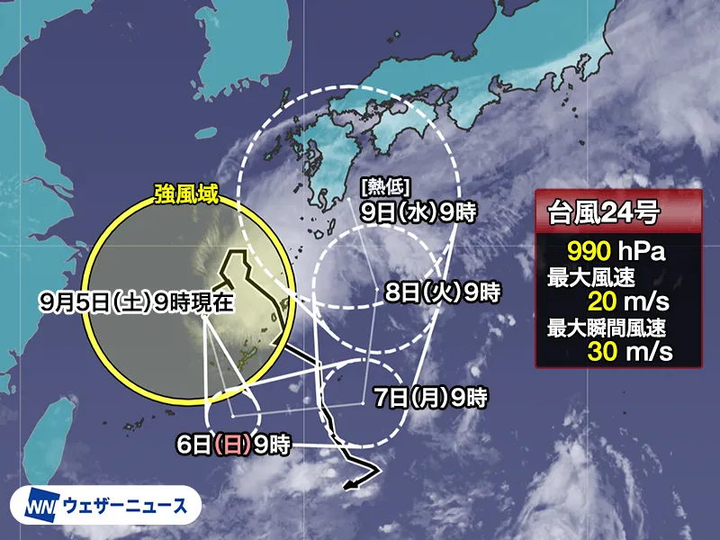
Rainbands are expected to drift away and gradually weaken overnight, but residents and visitors in Okinawa should remain indoors and avoid flooded streets until conditions improve. Forecast guidance indicates the system will turn east near the waters around Minamidaito Island while continuing to weaken. JMA does not expect Krovanh to strengthen or develop a 25 m/s “storm-wind” core.
Why the biggest risk is rain, not wind
This setup is more about moisture than raw wind strength. Even as Krovanh weakens, it is channeling very humid air toward Japan. At the same time, a separate tropical depression (around 998 hPa and below typhoon threshold) south of Japan is forecast to track north on Krovanh’s eastern flank, then become less organized as it approaches waters off Shikoku. That added plume of tropical moisture, plus an upper-level trough, will energize the autumn rain front (known in Japan as the shu-u/akisame zensen). The result: downpours may intensify far from Krovanh’s center.
Timing and areas at risk
The most concerning window runs from Sunday night, September 6, into Monday, September 7, when western and eastern Japan are likely to see periods of heavy rain. Shikoku and parts of western Honshu (including the Chugoku and Kansai regions) could be first in line, with the risk spreading into Tokai and Kanto, including the Tokyo metropolitan area. Localized torrential rain, lightning, and sudden gusts are possible near stronger cells. Because the exact placement of the front and moisture bands can shift, rainfall timing and hotspots may change; stay tuned to JMA updates and local authorities for the latest advisories, flood watches, and transport notices.
A notably active 2026 season
Japan’s world-class meteorological network has been tracking an unusually busy year. Through the end of August 2026, the number of tropical cyclones in the Western North Pacific has run about 10 above average. August alone produced 10 named systems—a pace not seen since August 1966 and only the third month with 10 or more since records began in 1951. While September typically sees slightly fewer formations than August (about five on average), the number of systems approaching mainland Japan (excluding Okinawa and Amami) actually tends to peak in September. Autumn cyclones also move faster, often increasing the potential for wind and water impacts in a short window. Remarkably, storms have formed in every month from January through September this year—a pattern recorded only in 1965, 2015, and now 2026.
Travel, daily life, and preparedness
Japan’s transport systems are proactive about safety, and temporary delays or cancellations may occur if rain intensifies—particularly on some regional rail lines, ferries, and domestic flights. If you live in or are visiting Japan, especially Shikoku, Kansai, Chugoku, Tokai, and Kanto, review local guidance, secure loose outdoor items, charge devices, and avoid driving through flooded spots. For real-time alerts, hazard maps, and multilingual resources, consult the Japan Meteorological Agency and your municipal office. Japan’s preparedness culture and resilient infrastructure consistently help reduce risk, but individual readiness remains essential during fast-evolving autumn systems.
Typhoon name note
Typhoon names in the Western North Pacific are drawn from a list of 140 contributed by countries and territories in the Typhoon Committee. “Krovanh” was proposed by Cambodia and derives from the Khmer word for the cardamom tree.
Bottom line: Even as Krovanh weakens, the combined moisture from the typhoon, a nearby tropical depression, and a sharpened autumn front could deliver significant rain to parts of western and eastern Japan from Sunday night into Monday. Stay weather-aware and follow trusted local updates.