Typhoon Dujuan develops in the Pacific
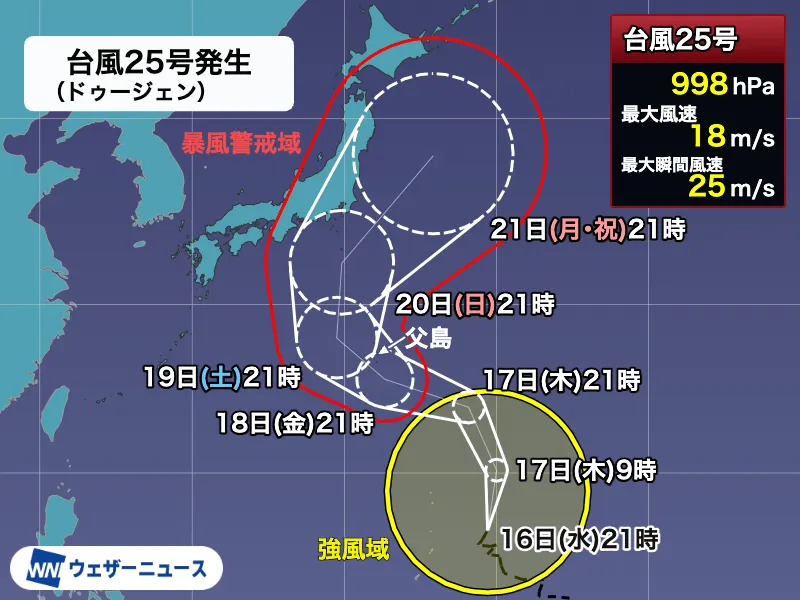
Typhoon No. 25, named Dujuan, formed over the Mariana Islands at 9 p.m. on Wednesday, September 16, according to the latest forecast information. The storm developed from a tropical depression and is currently classified as a large typhoon system, although its intensity category had not yet been assigned at the time of the report.
As of Wednesday night, Typhoon Dujuan was moving north-northeast at approximately 15 kilometers per hour. Its central pressure was 998 hectopascals, with maximum sustained winds of 18 meters per second near the center and maximum gusts of 25 meters per second. Forecasts indicate that the system could strengthen as it moves northward.
Ogasawara Islands urged to prepare for severe weather
The typhoon is expected to approach the Ogasawara Islands between Friday, September 18, and Saturday, September 19. The islands could experience strong winds, high waves and heavy rain, with the possibility of storm-force winds developing by Friday.
Residents, travelers and maritime operators in the Ogasawara Islands should remain alert to official warnings and prepare for rapidly deteriorating conditions. The remote island chain, located roughly 1,000 kilometers south of Tokyo, is especially dependent on sea and air transportation, meaning that ferry services, flights and other travel plans could be affected well before the storm’s closest approach.
Possible approach to eastern Japan during Silver Week
After passing near the Ogasawara Islands, Typhoon Dujuan is expected to continue northward and gradually turn westward along the edge of the Pacific high-pressure system. Current forecasts suggest that the storm could approach the Izu Islands and eastern Japan from Sunday, September 20, potentially affecting the Kanto region during Japan’s five-day Silver Week holiday.
However, forecasters emphasize that the storm’s future track remains uncertain. The forecast circle for Monday, September 21, has a diameter of approximately 920 kilometers. This large circle does not indicate the typhoon’s size or strength; rather, it shows that the precise route remains difficult to determine several days in advance.
Forecast simulations from meteorological agencies around the world show broadly similar trends, but the projected paths become more widely dispersed as the system nears Honshu. The strength of the Pacific high, the position of high pressure over the Asian continent and the timing and depth of an upper-level pressure trough could all significantly influence the storm’s track and timing.
Heavy rain could begin before the typhoon arrives
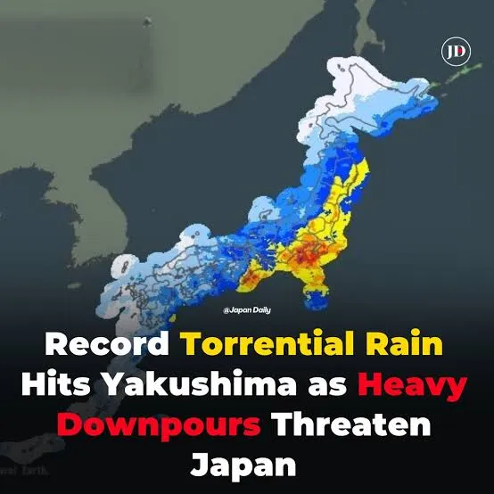
Japan is already experiencing a seasonal autumn rain front in the region. As Typhoon Dujuan approaches the waters south of Japan, it could draw humid air toward this front along the edge of the Pacific high-pressure system. This may intensify rainfall across parts of eastern and western Japan even while the typhoon itself remains far offshore.
Depending on the eventual track, some areas could receive substantial cumulative rainfall. The location and movement of the rain front, the typhoon and the upper-level pressure trough will determine when and where the heaviest rain develops. Transportation disruptions and changes to holiday plans are therefore possible during Silver Week.
Japan records an unusually active typhoon season
The formation of Dujuan marks the second typhoon of September, following Typhoon No. 24, Krován, and brings the 2026 season’s activity to an unusually high level. Ten typhoons formed in August, the first time since 1966 that a monthly total of 10 had been recorded. By the end of August, the cumulative number was approximately 10 above the long-term average.
In another rare development, typhoons have formed every month from January through September in 2026. Since records began in 1951, this pattern has occurred only twice before, in 1965 and 2015. September is also an important month for Japan because typhoons can move quickly and often approach the Japanese mainland, bringing strong winds and heavy rain.
The name Dujuan, written as 杜鹃 in Chinese, was proposed by China and refers to the azalea flower. Residents and visitors across Japan should check the latest information from the Japan Meteorological Agency and local authorities, secure outdoor belongings, review evacuation routes and avoid unnecessary travel in areas affected by severe weather.