Unusually active typhoon season raises concern across Japan
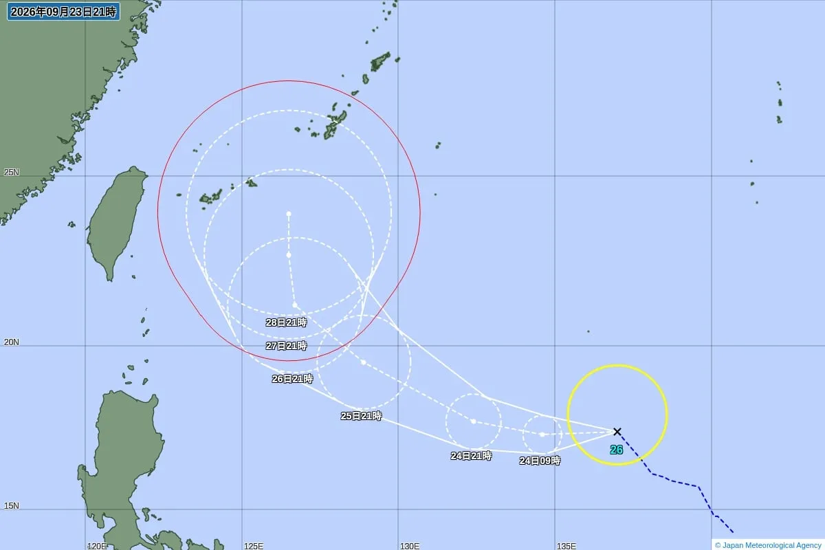
Japan is experiencing an exceptionally active typhoon season, with the Japan Meteorological Agency (JMA) confirming the formation of Typhoon No. 26, known internationally as Surigae, on September 23. The storm developed from a tropical depression over waters east of the Philippines.
The number is notable because 26 typhoons had formed by September for the first time since 1994—32 years ago, according to the JMA. By September 24, a total of 26 storms had formed in the western North Pacific, already exceeding the annual average of 25.1 recorded between 1991 and 2020.
August saw an especially rare burst of activity
The unusually high total was driven in part by a remarkable August, when 10 typhoons formed in a single month. That was the first time since 1966, or 60 years, that at least 10 typhoons had developed during August.
Eight typhoons formed between January and June, followed by five in July, 10 in August and three in September as of September 24. While August is normally the busiest month of the year for typhoon formation, this season’s activity has been far above typical levels.
Atmospheric waves and warmer seas may be contributing
JMA officials believe that unusually active atmospheric conditions from July through August played a major role. In particular, an atmospheric wave pattern known as an easterly wave was especially active. These waves can encourage the development and strengthening of towering thunderstorms over tropical waters, creating conditions in which tropical cyclones are more likely to form.
The agency also pointed to the possible influence of El Niño conditions, a climate phenomenon in which sea-surface temperatures become warmer than average across a broad area of the equatorial Pacific, stretching from near the International Date Line toward the coast of South America. Warmer ocean waters can provide additional energy for storm development, although the precise influence of climate patterns varies from year to year.
September and October still require vigilance
The end of August and September does not necessarily signal the end of the threat. In September and later months, upper-level winds can guide typhoons northward from the southern seas along curved paths toward the Japanese archipelago. When these systems interact with Japan’s autumn rain front, they can trigger prolonged and extremely heavy rainfall, even if the typhoon itself does not make a direct landfall.
Japan has experienced some of its most destructive historical typhoons during September. The Muroto Typhoon struck near Cape Muroto in Kochi Prefecture in September 1934 and caused 2,702 deaths. The Isewan Typhoon made landfall near Cape Shionomisaki in Wakayama Prefecture in September 1959, leaving 4,697 people dead. These disasters remain important reminders of the risks posed by storm surge, flooding, landslides and powerful winds.
Residents and visitors urged to monitor official information
The JMA warned that major typhoons can also form in October and urged people not to become complacent after the traditionally active months of August and September. Residents, travelers and foreign visitors in Japan should regularly check JMA forecasts, local government alerts and evacuation information, particularly when heavy rain is expected.
Japan’s detailed weather-warning and disaster-prevention systems provide valuable guidance, but conditions can change rapidly. People in vulnerable areas should identify nearby evacuation centers, secure outdoor objects, prepare emergency supplies and avoid rivers, coastal areas and steep slopes during severe weather. Continued attention to official updates will be essential as the unusually active season moves into autumn.