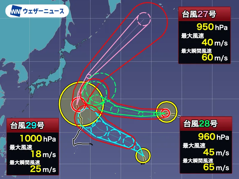
Three systems under observation southeast of Japan
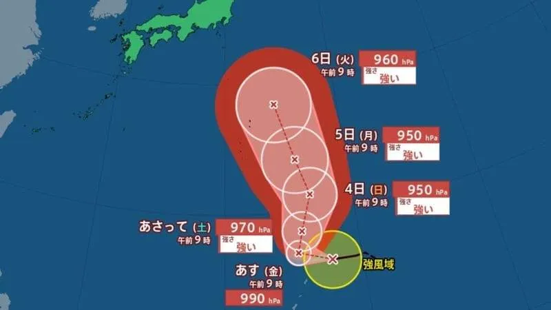
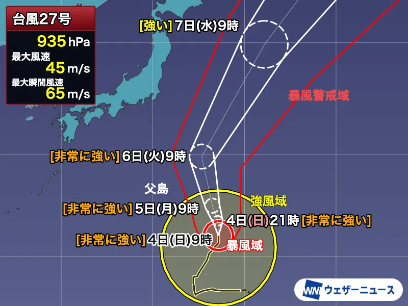
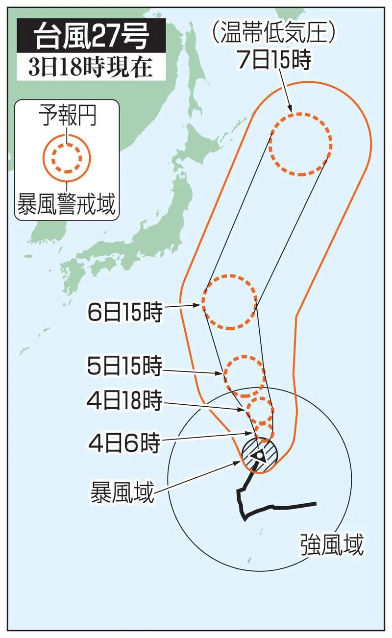
Three typhoons were present southeast of Japan as of 3 a.m. Tuesday, October 6, according to the latest forecast information. While Typhoon No. 27, Choi-wan, is expected to move away from the Ogasawara Islands, strong winds and high waves will continue to affect the region. Meanwhile, Typhoon No. 28, Nolo, and newly formed Typhoon No. 29, Koguma, could influence weather conditions around Japan’s upcoming three-day holiday weekend.
Forecast tracks remain subject to change, particularly for the latter part of the outlook period. Residents, travelers and foreign visitors in Japan should continue checking updates from the Japan Meteorological Agency and local authorities before making plans.
Typhoon No. 27: Strong winds and high waves continue
Typhoon No. 27, Choi-wan, was located near the Ogasawara Islands early Tuesday. The large and strong system had a central pressure of 950 hectopascals, maximum sustained winds of 40 meters per second near its center and maximum gusts of 60 meters per second. It was moving north at approximately 20 kilometers per hour.
Although Choi-wan has weakened from “very strong” to “strong,” a wide area of the Ogasawara Islands remains within its strong-wind zone. Strong winds are expected to continue on Tuesday, while rough seas and high waves accompanied by swells may persist through Wednesday, October 7.
The storm’s effects will not be limited to areas close to its center. Along parts of Japan’s Pacific coast, waves of around 3 to 4 meters are forecast, and some locations may also experience stronger winds because of the surrounding pressure pattern. Even regions outside the projected track should remain cautious, particularly people involved in marine activities.
Typhoon No. 28 could change direction later
Typhoon No. 28, Nolo, was positioned near Midway Atoll early Tuesday. It was classified as a very strong typhoon, with a central pressure of 960 hectopascals, maximum winds of 45 meters per second and gusts reaching 65 meters per second. The system was moving west at around 25 kilometers per hour.
Nolo developed from a tropical depression that formed off Mexico in the first half of September. After crossing the Pacific, it strengthened into a hurricane near Hawaii. Once it crossed the 180-degree meridian, or International Date Line, it entered the monitoring area of Japan’s weather agency and was designated a typhoon.
The system appears to have reached its peak intensity and is expected to gradually weaken while continuing westward. Later, it may curve around the edge of a high-pressure system and turn toward the northeast. Forecast models differ on how far west Nolo will travel before changing direction, making continued monitoring important.
Typhoon No. 29 may strengthen
Typhoon No. 29, Koguma, was located near the Marshall Islands early Tuesday. It had a central pressure of 1,000 hectopascals, maximum winds of 18 meters per second and gusts of 25 meters per second. The storm was moving slowly toward the north-northwest.
Koguma is expected to turn toward the west-northwest and move broadly parallel to Nolo. Unlike Typhoon No. 28, it is forecast to strengthen as it travels westward and could reach strong typhoon intensity by Friday, October 9. Depending on its eventual path, the Ogasawara Islands and the Izu Islands could face impacts around the holiday weekend, with unsettled weather potentially spreading to the Izu Islands after the weekend.
Forecast uncertainty remains significant
Numerical simulations produced by meteorological agencies around the world generally show both systems moving northwest before turning northeast. However, the forecast paths spread considerably later in the period. A more easterly track would likely bring limited effects to Japan, while a farther-west track could bring one or both systems closer to the Ogasawara Islands and the Izu Islands.
Because these forecasts extend several days into the future, uncertainty remains substantial. Forecast confidence is expected to improve as new observations become available. Travelers should check transport updates, ferry schedules and local weather advisories before visiting islands or coastal areas.
Busy typhoon season adds to concern
Typhoon activity in 2026 has been running well above average. By the end of September, the cumulative number of storms was approximately seven higher than the climatological average, and three additional typhoons formed after October began. October typically sees 3.4 typhoons, meaning the active season may continue for some time.
Autumn typhoons can be especially disruptive because they often move faster than summer systems and may bring damaging winds, heavy rain and sudden changes in conditions. Japan’s residents and visitors are advised to secure outdoor items, prepare emergency supplies, review evacuation information and avoid coastal areas during periods of high waves.
This year is also notable because a typhoon has formed every month from January through October. Since records began in 1951, the same pattern has occurred only in 1965, 2015 and 2026.
Understanding the storm names
Names for typhoons in the western North Pacific and South China Sea are selected from a list of 140 names proposed by members of the international Typhoon Committee. Choi-wan was proposed by Hong Kong and refers to a Chinese term associated with a colorful cloud, while Koguma was proposed by Japan and means “little bear,” referring to Ursa Minor. Japan’s proposed names are based on constellations, reflecting neutral and familiar natural themes. Nolo, meanwhile, retains a name assigned through the U.S. National Hurricane Center because the system originated in the eastern Pacific before crossing into the western North Pacific.